


Giant crabs, ‘vegetable soup’, telltale terraces, brazil-nut rocks, undersea mountains and a surprisingly warm heart are all among Taranaki's hidden mysteries. Geologist Vincent Neall has studied the New Zealand region's earthly wonders since 1968 and continues to be stunned by his findings. With the enthusiasm of a children's storyteller, Vince picks out seven marvels that make the bump on the North Island's west coast so unique.
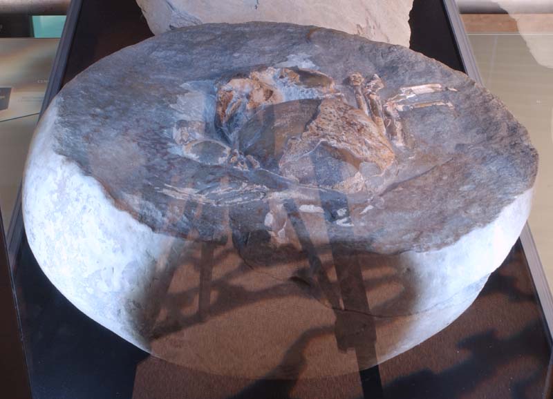
Crack open a rock in east Taranaki and you may find a fossilised crab that's millions of years old. These extinct crustaceans are called Tumidocarcinus giganteus, says Vince, an associate professor at Massey University. "They are giant fossils and have great big pincers on them," he snaps the air with his large hands.
The fascinating aspect of the creature's claws was the difference in size between right and left. On males, the right claw could grow up to twice the size of the left. "The biggest I've seen is about 40cm," Vince says. It's believed the over-sized claw was used for fighting, feeding and signalling to attract female crabs.
These deep-water creatures scrabbled sideways along the seabed during the Miocene period. Vince says the crabs are a unique feature of eastern Taranaki and can be found hidden in boulders from the Tāngarākau Gorge northwards to the Waikato. While most people would have no idea how to find a crab fossil, there are collectors who know exactly where to fossick out these ancient rocks, and how to chisel them out of boulders.
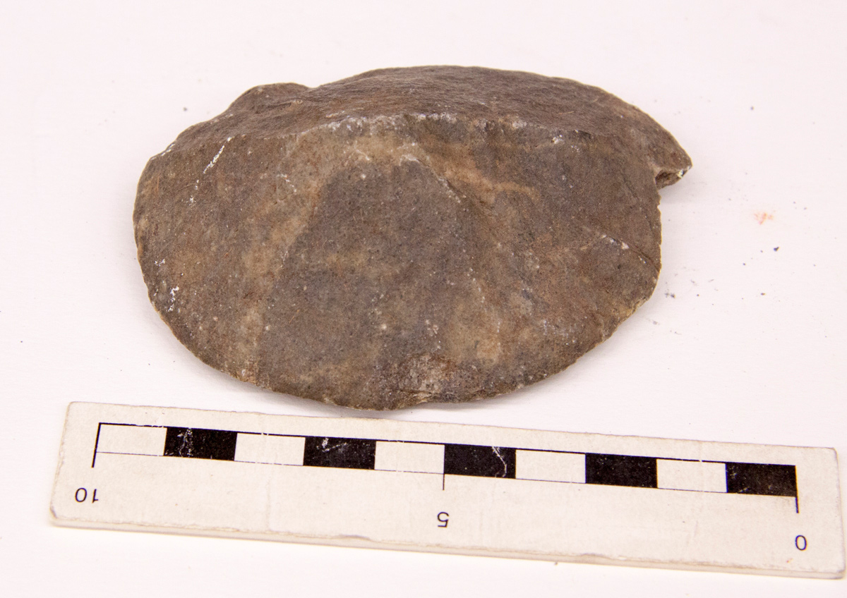
There are more rocky stories along Taranaki's coast. At the mouth of the Waitōtara River and on the beaches going south to Whanganui are tumbles of weird stones shaped like Brazil nuts. They look like the work of extra-terrestrial sculptors, hell-bent on leaving signs on earth. In reality, their makers are definitely of this land, for it is the wind and sand that have formed these strange offerings, called ventifacts.
These natural artworks are found in Death Valley, California, the Sahara Desert in Africa, Antarctica – and Taranaki.
"They represent very hard rocks that got polished by the wind blowing sand grains across them. They polish the rocks into a variety of shapes and some can be quite magnificent in their forms," Vince says. Each stone has been shaped over thousands of years, but can be plucked off the sand in a moment.
There has been a problem with beach goers picking the rare stones off the beach, some even taking away trailer loads. "The Geological Society of New Zealand thought we had to make a move and preserve them for future generations." Vince says there are areas along the Taranaki-Wanganui coastline that are now ventifact reserves. This means people are not allowed to take them off the beach, and it is also illegal to sell the ventifacts.
While that conservation message is straightforward, the origins of the quartz stones are not. "The rocks that make the ventifacts – we don't know where they come from," Vince admits. But the scientist's brain works like a detective: "They probably came from the South Island by long-shore drift up the former shoreline when Taranaki and Nelson were joined together." He explains how the two areas were once joined by a land bridge, which was slowly broken down by the sea. "Long-shore drift then took them (the rocks) down the Taranaki coastline into the Wanganui district." But Vince says these are just theories. "It's one of Taranaki's mysteries."
Another has now been solved. "Way back in about 1860, geologists were investigating the Sugar Loaf Islands and they noticed a unique mineral forming veins within the rock," Vince says. The scientists were puzzled – this was a mineral they had never seen before. They examined it, wondering if they had discovered something new on earth.
"It's a phosphate mineral and was named 'taranakite'," he says. "So Taranaki has a mineral named after it."
After a great deal of puzzling, the origins of the strange veins were uncovered. "We now know that this mineral was bird guano." In other words, Taranaki's own mineral is in fact bird poop!
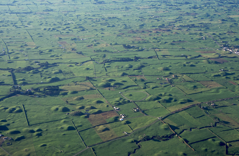
The region's rocky wonders continue around the coast between Ōkato and Opunake, where the land is as lumpy as a teenager with acne. Below Mount Taranaki, known in geological terms as Egmont Volcano, the dairy pastures are spotted with thousands of conical hills. These were created by a massive lahar, following the collapse of the mountain's cone about 22,000 years ago. "Which was the volcanic cone prior to the current Egmont cone," Vince says.
"It collapsed to the west and this huge avalanche of material left behind all this debris." This is called the Pungarehu Formation, which extends beyond the coastline at Cape Egmont. Vince explains how it was formed: "The best analogy is if someone tipped vegetable soup on the table – the liquid will flow off the table, but leave the peas and carrots behind."
Puke Ariki historian Ron Lambert has another edible explanation: "A lahar is a bit like a plate of porridge spilled on a sloping surface. You could think of the rocks and debris as raisins. As the porridge travels down the slope, it slows. The raisins stop moving and little bits of the slurry form around them." In the centre of each mound is a core of large rocks and debris, which for many years have been quarried for roading metal, Ron says.
Vince says there is some evidence that an eruption may have triggered the western lahar. "The analogy is with Mount St Helens, where two-and-a-half cubic kilometres of rock slid sideways and travelled 20km down a nearby valley," he says referring to the 1980 eruption in the State of Washington on the United States west coast. "The net result was a landscape of conical hills like we have here (in Taranaki)," he says.
Turn off the main road in South Taranaki and ride the terraces of time. Vince Neall says this area has a spectacular sequence of uplifted terraces that tell stories of the world's changing climate. "People drive across them all the time when they go up and down from Whanganui to Hāwera. If you took some of these side roads, you drive along and up … the road literally climbs a small cliff and goes up another terrace," he says. "The reason these terraces have formed is globally significant because probably one million years ago they were under the water and this is the record of them being uplifted from the sea."
Vince explains how these terraces clearly document the ice ages and warm periods of the earth's life. "During the last ice age, the sea went way out beyond its present shoreline and Taranaki was joined to Nelson. Animals were free to travel from the North and South Islands. The Cook Strait Canyon was still there further to the southeast, separating Wellington from Marlborough," he says. Then the weather gradually changed. "When the warm periods of climate occur, in comes the sea. We are living in one of these episodes today and it's cutting a cliff around most of Taranaki."
Using his hands to mimic the movement of the sea, Vince explains further: "Immediately offshore, the waves are coming in and the rocks are moving and rolling around and they are cutting into the soft sedimentary rocks underneath." This is forming a platform right around Taranaki. "The next time the climate changes and the sea goes out, this marine terrace is preserved."
This has happened time and again, which is how the terraces of South Taranaki have been formed. Like the rings on a tree, which show how old the specimen is, the terraces reveal how many ice ages there have been. It is all there, like the scars and calluses on a farmer's hands. "They then of course record all these periods of the earth's climatic fluctuations – that's why they are globally significant, because we can work out how old they are," Vince says. More terraces of time can be found at Tikorangi.
Looking much further, into the depths of the region, scientists have found more surprises. "Over the last 10 years, there have been some studies done in the Taranaki region on the amount of heat escaping from the earth," he says. "We find, in areas like the Taupō volcanic region, the heat rising to the ground is significantly higher than elsewhere due to the thinness in the earth's crust."
North Taranaki is also showing signs of having a warm heart. "There is an anomaly in the New Plymouth region, but not as noticeable as Taupō. The calculations that have been done on this thermal anomaly show that this portion of the earth's crust is probably still cooling down from the volcanic activity of the Sugar Loaf Islands, Paritūtū, Kaitake and Pouākai." Vince says the higher temperature in New Plymouth is only slight. "It can only be picked up by geological instruments."
There are more hidden wonders at sea. "Off the North Taranaki coastline, the offshore oil prospecting has discovered extinct volcanoes that were comparable in size to Egmont (Mount Taranaki). They have sunk with time and been buried by sediment," he says. These volcanoes date back to the Miocene Period, the same time the giant deep-sea crabs, Tumidocarcinus giganteus, scuttled on the ocean floor from 24 to 5 million years ago.
Please do not reproduce these images without permission from Puke Ariki.
Contact us for more information or you can order images online here.


