

Hill Road is a winding road near Egmont Village which curves past a remarkable hill with a long geological and social history tied to many facets of our province’s past.
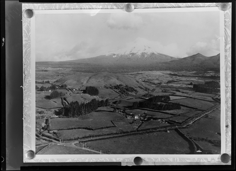
The origin of the name Hill Rd is clear to anyone driving towards Taranaki maunga along this road. Halfway down the road on the left-hand side a significant dome rises 312m above sea level. This well-known landmark is known locally as German Hill.
It appears that Hill Rd wasn’t called German Hill Rd because up until about the 1930s there was another short road which connected Hill and Maude Rd along the back of German Hill, and this was called German Hill Rd.
Before being named German Hill the dome was known as Atoa Iwa by Ngāti Tawhirikura and Ngāti Te Whiti hapū of Te Ātiawa iwi. It was used as a kāinga, offering commanding views over the surrounding land.
How then did this landmark and former kāinga become known as German Hill? In a Taranaki Herald article from 1964 various possibilities were floated, including a story involving German sailors spending a night on the summit of the hill while on leave from their vessel.
The most probable reason for the European name was that the hill sat in an area known as ‘German Settlement’ in the 1860s and 70s. The block, which roughly spanned the section of land between Albert Rd/Hill Rd and Kent Rd and running from State Highway 3 to Egmont National Park/Te Papakura o Taranaki, was set aside for a planned settlement of German immigrants to Taranaki in the 1860s.
However it appears this plan was shelved at this time, possibly due to concern by immigrants at news of the Taranaki wars.
So eventually this portion of land was instead set aside as a military reserve, and then sold to settlers but it retained the name of the ‘German Settlement’ well into the 1880s.
On maps at this time the hill was first marked as Atoa Iwa/German Hill, and then later, just German Hill.
Over the years to add to the confusion, the hill’s name was associated with the later arrival of German (actually Polish) immigrants who settled nearby in the Inglewood and Midhurst areas from the mid-1870s.
The hill itself is fascinating geologically as well as it was formed during one of the Mt Taranaki volcanic periods. Around the base of the volcano that makes up Mt Taranaki, faults and fractures mean sticky lava has been able to ooze to the surface and these have formed steep, rounded hills, known as cumulodomes. German Hill is one of these. Other examples are Pukeiti, the Beehives on the mountain’s southern sides, Skinner Hill and the Dome on the north-western slopes.
Documents
Taranaki Herald column, 6 March 1872
Hill Road landscape, Puke Ariki Collection WD.000001
Please do not reproduce these images without permission from Puke Ariki.
Contact us for more information or you can order images online here.
The information on this website is provided for general research and reference only. While we try to keep content accurate and current, we make no guarantees about its completeness or correctness. It should not be considered a replacement for a LIM or a Property Report. Some content is supplied by third parties. Puke Ariki has not verified this content and users should check its accuracy before relying on it.The inclusion of a building on the website does not imply heritage status. See SCHED1 in the NPDC District Plan for a list of buildings that have rules about what can happen to or around them (administered by NPDC). See the New Zealand Heritage List for a list of buildings that are celebrated for their heritage significance but are not subject to rules (administered by Heritage New Zealand Pouhere Taonga). Should any corrections need to be made to the records or for more information please contact us.


