


The first ever Māori gun fighter pā excavated in New Zealand has revealed a telling clue about its past. As archaeologists sieved through soil of a major site at Bell Block in Taranaki, they found a shard of drawing slate. On it was a side-view sketch of a cloak-clad Māori warrior looking down the barrel of a musket. A slate pencil was also uncovered on site.
Auckland University archaeology lecturer Simon Holdaway says the slate helped piece together details of the function of the site, called Te Oropuriri. "To make sure that we knew what we were digging, they left us a picture," he says.
Archaeology North's Michael Taylor has studied the illustration closely and believes Māori probably sketched it. "It was drawn in a 'naive' style. One eye is bigger than the other." He discounts the chances of it being drawn by a British soldier or Pākehā immigrant: "Europeans have a long history of drawing things in a realistic fashion."
Simon Holdaway says that getting the chance to investigate a Māori gunfighter pā is a rare event. "We don't generally get to excavate because they are tapu - because people died over them. This was unlikely to have been fought over."
He explains why. "We've not found many lead bullets or musket balls here." Normally, a gun fighter pā would be scattered with thousands of bullets, quickly forcing archaeologists to stop digging and consult tangata whenua (the people of the land), in this case the Puketapu hapū (a sub-tribe of Te Ātiawa). A lack of bullets initially put investigators off the scent of gunpowder. When they began the dig, archaeologists thought they were just excavating a large house.
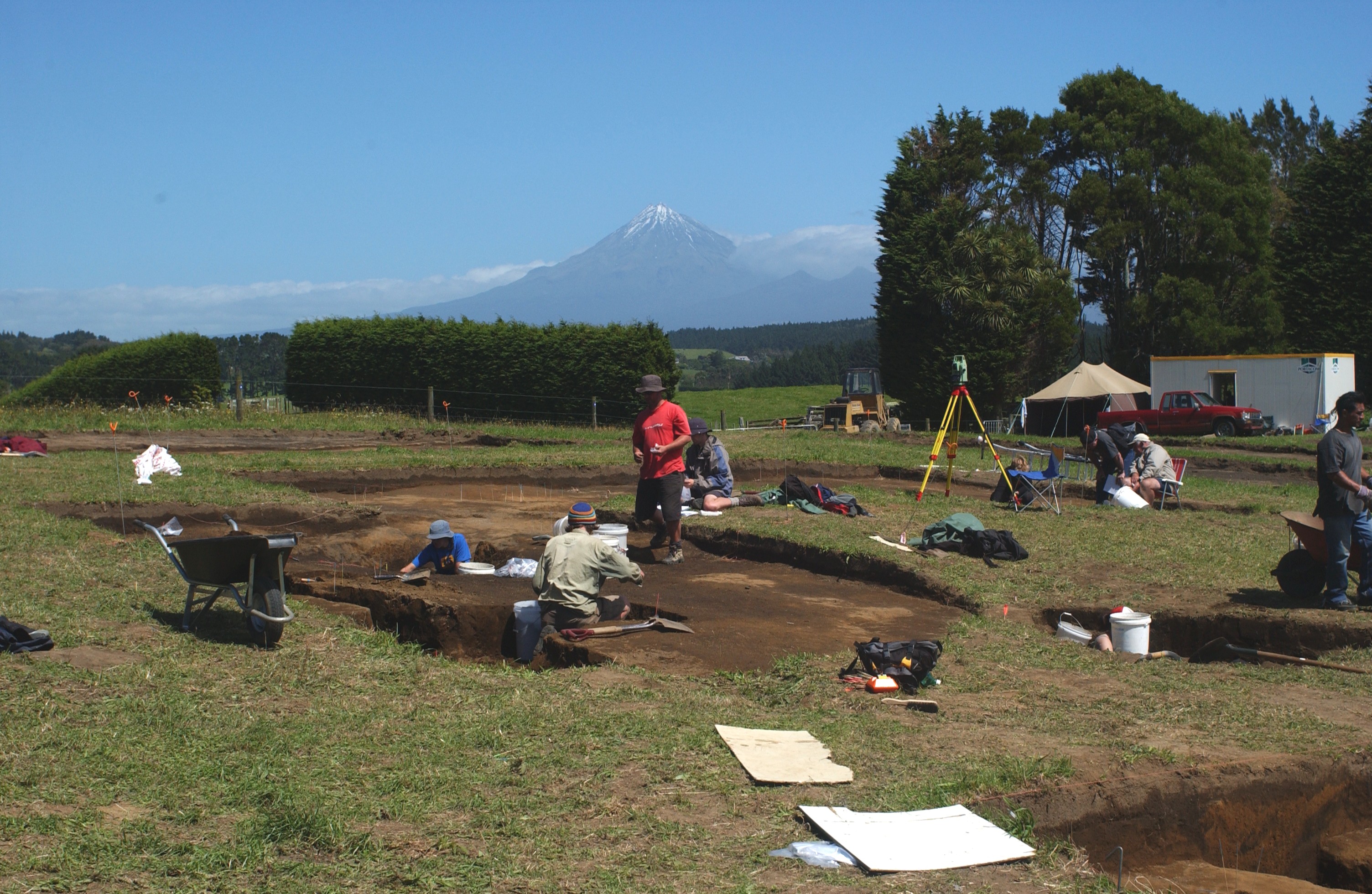
The three-pronged team, made up of students and lecturers from Auckland University's anthropology department, plus contractors Archaeology North and Geometria, began working on the site in 2002.
That's when Michael Taylor originally found remains of a Māori settlement. First, he spied evidence of a ring-ditch pā about 50 metres south of an urupā (Māori burial ground), near the old highway. The hillock pā was an easy find. "It's a fairly obvious archaeological site from the shape of it and because there's archaeological material eroding off it," he says. Bits of bottles, glass and china can be clearly seen in the rich Taranaki ash soil.
Next, the Whanganui archaeologist stood on an expanse of grassy paddock between the pā and urupā. The ground seemed lumpy and careful observations revealed the outline of a massive shape. "We saw this large rectangular depression that was very well defined and conformed with what we would expect for a Māori house, except it was so large that we were reluctant to call it a house at that stage," Michael says.
Puketapu hapū elder Grant Knuckey was then called on to revisit the site. "We were looking at a paddock with grass and basically it was flat," says Grant. The archaeologist pointed out subtle differences in the shape of the field. "What he was saying was quite true - the lines were different and it looked like a big oblong in the grass."
After a closer inspection, Michael asked if a preliminary dig could begin, with just two or three people on site. That was agreed to.
Excavations have shown the remains of not just one wharenui, but possibly three. It is believed the top layer was built in the 1860s, while the two beneath have yet to be dated.
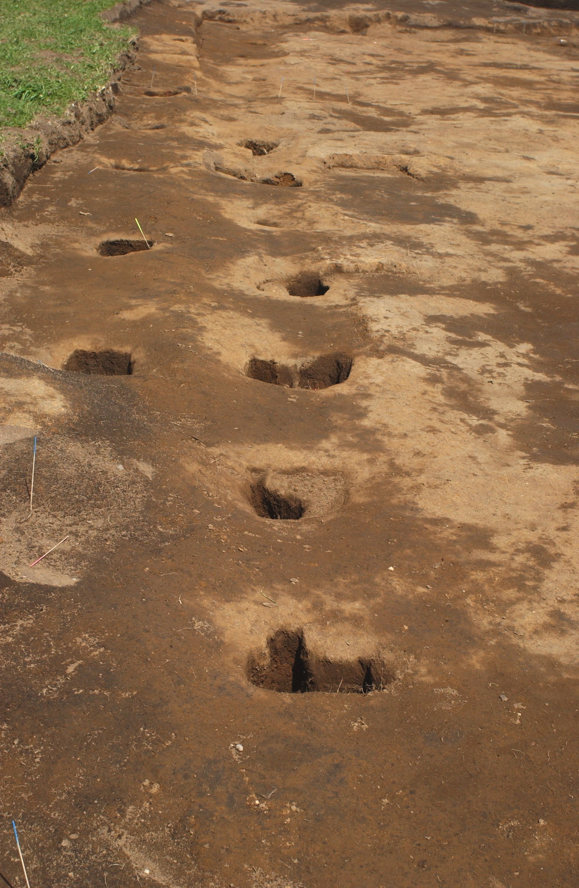
In 2004, a much larger group of archaeologists returned to Te Oropuriri to complete their investigations. Further digging uncovered what looked like storage pits for the house. As they dug deeper and wider, they found an intricate network of trenches. Eventually, they realised they had stumbled upon a gunfighter pā. Simon Holdaway points to a long pit: "I'm almost certain that's a bunker. Māori invented trench warfare."
He explains how early Māori fortifications were palisade pā or stockades. These were effective until Europeans brought muskets to New Zealand. Simon says the early musket attacks on the palisade pā were extremely one-sided because warriors inside the fortress were sitting ducks. Quickly, the pā sites were rebuilt to include rifle pits, artillery bunkers, flax screens and inner stockades.
At Te Oropuriri, the uncovered fortifications began to look like a work of art. "This is all lovely curves," Simon says. As well as the picture of the Māori warrior, the diggers have also uncovered a rua, which is a large bowl-shaped underground storage structure. Sitting on top of shellfish remains were 20 empty gunpowder flasks and loose flask caps. Above them, the diggers found four or five dog skeletons and about three dogs found in pieces.
Michael Taylor says it is likely British soldiers destroyed the pā site, killed the dogs, threw their remains in the rua and filled in the trenches and rua with soil. He says the flasks would have been used to restock personal containers. "They were made of iron and painted bright orange. There was no residue of gunpowder at all." The corroded flasks, which are about the size of a 750ml water bottle and pear-shaped, are now undergoing stabilisation treatment. Just hours after being exposed to the air, the effects on the metal were obvious. Instead of being bright orange, the containers had oxidised to rust-brown.
Researcher Kelvin Day says that after being in a constant environment for so long, artefacts such as these are subject to shock. "We see that in wood articles coming out of swamps and, particularly with metals," he says. "They (the flasks) have been in a damp, cool, but constant environment for more than 100 years, so now they have to be treated to stabilise them so they can survive in a different environment. The flasks had to be moved with extreme care. "Any little jolt and bits will break off. They are very fragile."
Signs of other ammunition have been found at Te Oropuriri. Michael Taylor says lead musket balls were made on the site and the team has found spills of molten lead that have formed small hollows in the ground. "None of it's been fired," he says.
Since digging began in 2002, both tangata whenua and the archaeologists have known little about the site.
"Our people must have lost contact with it somehow," Grant Knuckey says. Slowly, the site's past is coming to light. "People have come forward with little maps and said 'We knew the tunnels were there all the time'. These were our people, who lived 100 metres away and they didn't say anything, which was a pity. They feel that confidence (to speak) now."
Grant says that if Puketapu people had told someone that there was a wāhi tapu (sacred site) there, NZTA would have taken a different route. "They would not have got a licence to go through the area." Sacred sites are protected through the New Plymouth District Council's district plan. "Any development within 50 metres of a known site is banned," Grant says. "You can't build houses and you can do nothing that may in effect damage the site."
However, the site was only found when the bypass excavations began. "Things that don't want to be found are best not found. Not all things are good," he says. "This site was not a battle site - there are no signs of slaughter on it." Grant says it was found for some reason. "It's a site that revealed itself at this time and has wanted to tell us about itself. It's real history, not out of a book - 'this is the shape I am; I'm not imaginary'."
Michael Taylor says an 1848 map indicates it was a large pā. "It is shown as a double square. It probably means it was a bigger pā than most of the pā in the district." That was all the team knew - until researcher Ron Lambert came to the rescue. "It was one of the villages fortified during the Puketapu Feud," he says, producing a copied page from the book, Samuel Ironside In New Zealand.
The extract outlines what the Reverend John Whiteley saw around New Plymouth in 1856. "This Circuit, having been in a state of war for the last two or three years, is now composed of a number of pās (sic) and stockades, each little settlement being converted into a military fortress for the security of the inhabitants thereof. These pās [sic] are generally situated along the main road - called Devon Line - and number nineteen from Te Kawau in New Plymouth, to Turangi, five miles north, or Waitara." Number Six on the list is Te Oropuriri.
Grant Knuckey says that in the mid-1800s, the Irish regiment of the British army was sent to destroy all the pā. "And that's what they did. So our people had no place to live. That's why they ended up at Parihaka." Kainga (villages) like Te Oropuriri were stopping-off places for North Taranaki iwi and hapū heading to Parihaka for celebrations on the 17th and 18th of each month. "They would've come through this way because they knew there was hospitality and shelter."
But relations between Māori weren't always friendly. Historians say that in 1854, the land north of New Plymouth was the subject of a bloody feud between factions of the Puketapu hapū. Rawiri Waiaua and his supporters had already helped sell hapū land to European immigrants, a move that infuriated Katatore Waitere, Pārata Te Huia, and their followers.
About 1848, negotiations began over the sale of land known as the Bell Block. A few years later, Waiaua was later pressed to sell more land in the same district because settlers continued to arrive in Aotearoa seeking land. While inter-Māori relationships had been tested over the Bell Block, the proposal to sell further hapū land sparked full-scale warfare.
This is detailed in Benjamin Wells', The History of Taranaki, published in 1878. “Early in the morning of the 3rd of August, 1854, Rawiri and a party of his followers went out with billhooks to cut a line for the purpose of marking the boundaries of a piece of land they intended to sell to the Europeans,” writes Wells. “While they were engaged in the work, they were met by an armed party under the command of Waitere Katatore, who fired upon them, killing four persons, mortally wounding Rawiri and another, severely wounding four, and slightly wounding six. Out of Rawiri's 26-strong party, 16 were hit.”
The Puketapu Feud lasted about four years. “Sometimes a skirmish took place among the hedges of the settler's farms, and occasionally bullets pierced their houses, but no Pākehā was injured," says Wells, who was the editor of the Taranaki News from 1874 until his death in 1881. “‘At length, a truce was made in 1856, after 60 Māoris [sic] had been killed and 100 wounded.”
Ron Lambert says the feud actually rumbled on until about 1858. This is backed up in Wells' book, which reports that in early January 1858, Katatore was ambushed and killed by a party of five Māori on horseback.
While the conflict pitted Māori against Māori, it also had other effects.
"It was the Puketapu Feud that initiated the settler demand for Imperial Regiments to be stationed here," says Ron. "They set up at Marsland Hill." Further stockades were erected around Taranaki throughout the 1860s. One of those was the Bell Block Stockade, immediately across Devon Road (SH3) from Te Oropuriri.
Standing on the site in 2004, Michael Taylor says no other pā from the 1850s has been excavated in the region. "It's of national significance and is an important time in Taranaki's history. It fills a gap, because in the 1850s there was no large-scale conflict with Europeans, so what went on wasn't very well documented. It was Māori against Māori."
Michael says that in 1860, when the New Zealand Wars began Te Oropuriri was likely to have been taken by the British. Perhaps two years later, Māori went back to the site and built the big wharenui on top of the site
Clues to the age and fate of the 72 foot-long (22 metre-long) house can be found in the earth. "Investigations showed that it was a very large house with European elements - windows, nails instead of binding," Michael says. However, the house still retained some strongly Māori traditions, including fireplaces down the centre of the house, a smooth, flat dirt floor, and there were also indications that decorative carvings had been in place.
The date of the house can be found in its hearths. Archaeologists have found a number of broken clay tobacco pipes in the fireplaces of the house. These disposable pipes were made no earlier than 1861 and no later than 1862. This can be deduced because the clay pipe manufacturer (Davidson of Glasgow) began making his wares in 1861.
Michael believes the house may have been taken over and destroyed by British soldiers. He says several buttons off military uniforms, steel heel plates from soldiers' boots and ammunition from British Enfield rifles have been unearthed. These have been found in the top level of the site, indicating they were the last people to have occupied the site. "There's been a lot of alcohol drunk and bottles have been smashed against the house - that's not the sort of thing you would expect Māori to do to a house of that size," he says. "There are all sorts of values that Māori have that apply to houses - tradition and symbolism that carries on through to modern day. Māori don't eat in a meeting house." Therefore, they were also unlikely to be drinking and smashing bottles against a sacred building. "It was also illegal to sell alcohol to Māori in those days," Michael says. It was, therefore, highly unlikely Māori would be drinking liquor in full sight of Devon Road. "You can imagine (British) troops doing that." Also, it is known that soldiers opened their bottles by whacking the top off with a large knife or bayonet. There was plenty of evidence that this had occurred at Te Oropuriri.
Māori houses are the speciality of Rod Wallace, the technical officer of Auckland University's Anthropology Department. He says that from the early to mid 1800s, Māori meeting houses overtook war canoes as the main focus of an iwi. "All their efforts began being focused on the Māori meeting house - as it is today. Houses were built for events."
In Taranaki, there are other Māori houses of a similar size and age to Te Oropuriri. In 1853, construction of two houses began. One, called Taiporohenui was built at Manawapou, and the other, called Kumeamai te Whaka, was located at Ketemarae. In May 1854, a meeting of many different iwi was held at Taiporohenui to form a united front against the selling of land to the Europeans. The house was 120 feet (36 metres) long and 35 feet (10.5 metres) wide and was the largest in the country.
Another was Te Ika-roa-a-Maui on the coast at Pungarehu, where Colonel Warre and his troops spent a night on 12 June 1865. This house was said to have been more than 100 feet (30.5 metres) in length. A later house was Rua-toki te hau at Puniho marae, which was built in the mid-1870s. Its facade can be seen in Takapou Whāriki, the Taonga Māori Gallery within Puke Ariki.
Hans-Dieter Bader, of Geometria, says modern electronic survey equipment has been used to collect information on the site. The collated data will be used to re-create a computerised 3D model of what Te Oropuriri would have looked like during its different stages.
Hans has already been part of the Cornwall Park centennial project, which involved piecing together a computerised journey through a fortified pā called Maungakiekie that was excavated on the side of One Tree Hill. "There is a large amount of archaeological information in the flyover," he says, of the animated moving picture on his laptop screen. "It's so easy for people to see. That's what we want to end up with here," he says of the Bell Block site. Grant Knuckey says the technology takes people back to the site's past. "You don't have to put a whole lot of words together to get a picture. They have brought it to life."
Buist, A.G. (1964). Archaeology in North Taranaki, New Zealand a study of field monuments in the Pukearuhe - Mimi-Urenui area. Wellington: New Zealand Archaeological Association.
Chambers, W. A. (1982). Samuel Ironside in New Zealand, 1839-1858. Auckland: Ray Richards Publisher: Wesley Historical Society of New Zealand.
Prickett, N. (1981). The archaeology of a military frontier: Taranaki, New Zealand, 1860-1881.
Walton, A. (2000). Archaeology of the Taranaki-Wanganui region. Wellington: Department of Conservation.
Wells, B. (1878). The history of Taranaki: a standard work on the history of the province. New Plymouth: Edmondson & Avery.
Please do not reproduce these images without permission from Puke Ariki.
Contact us for more information or you can order images online here.
The information on this website is provided for general research and reference only. While we try to keep content accurate and current, we make no guarantees about its completeness or correctness. It should not be considered a replacement for a LIM or a Property Report. Some content is supplied by third parties. Puke Ariki has not verified this content and users should check its accuracy before relying on it.The inclusion of a building on the website does not imply heritage status. See SCHED1 in the NPDC District Plan for a list of buildings that have rules about what can happen to or around them (administered by NPDC). See the New Zealand Heritage List for a list of buildings that are celebrated for their heritage significance but are not subject to rules (administered by Heritage New Zealand Pouhere Taonga). Should any corrections need to be made to the records or for more information please contact us.


